Best GPX to STL converters in 2026: 10 tools compared
GPXtruder, TerraPrinter, TrailPrint3D, Printed Canyon, TouchTerrain, MeshQuad Topo, GPXTrack.xyz and more compared with TrailMark3D: input, STL or 3MF, terrain or route only, colors, price.
By Carlo ·
In short
For a terrain map with your route on it, ready for a multi-color printer, use a browser tool that makes the terrain and exports 3MF, such as TrailMark3D, Printed Canyon or TerraPrinter. For a free, open-source model of the route line or its elevation profile, use GPXtruder or GPXTrack.xyz. For terrain only from elevation data, use TouchTerrain. If you already model in Blender, TrailPrint3D works inside it.
A GPX file is a list of points with a latitude, a longitude and usually an elevation. To 3D print it you need a tool that turns those points into a solid model: an STL, or a 3MF when you print in more than one color. The tools that do it differ a lot. Some model only the route line, some model the real terrain around it, and only a few keep the trail, the land and the water as separate colored parts.
We make TrailMark3D, one of the tools below, so we've kept the comparison to facts each tool states on its own site, with links, and say where another tool is the better pick. We first checked the tools on 3 November 2026, and on 13 November 2026 added TerraPrinter, MeshQuad Topo and GPXTrack.xyz and updated TrailPrint3D. Tools change, so check the site before you rely on a detail.
The comparison at a glance
| Tool | Starts from | Models the terrain | Download | Multi-color | Runs | Price |
|---|---|---|---|---|---|---|
| TrailMark3D | GPX files, or any place by name or coordinates | Yes, with water, roads, landcover and city buildings | STL and 3MF | Yes, each part on its own filament in the 3MF | In the browser | Free plan, Pro for more |
| Printed Canyon | A GPX file, a place search, a city, a country or US state | Yes, and city maps with buildings, roads, water and parks | STL, 3MF and GLB | Yes, the route or each city layer as its own part in the 3MF | Online | Free, pay what you want |
| TerraPrinter | Any place you search or draw, or a GPX route for its race medal model | Yes, with buildings, roads and water | STL and 3MF | Yes, 3MF | In the browser | Free for personal use and for selling up to $5,000 a year with a credit; a license above that |
| GPXtruder | A GPX file with elevations | No, the route itself as a ribbon, a profile or a ring | STL, plus OpenSCAD code | No | In the browser | Free, open source |
| GPXTrack.xyz | A GPX file | No, the route itself as a figurine on a base, with text | 3MF | No | In the browser | Free, open source |
| TouchTerrain | An area on the map or a KML polygon | Yes, terrain only | STL, OBJ and GeoTIFF | No | Online, or a Python script | Free, with processing quotas |
| TopoTrail | GPX files | Yes, with water, land and rock colors | 3D printing formats (not listed in detail) | Separate colors listed | In the browser | Free, as listed |
| MeshQuad Topo (TopoMeshLab) | Any place on the map, with a GPX file or a trail picked on the map | Yes, with color layers and labels | 3MF, plus a ZIP with one STL per part | Yes, 3MF by color layer | In the browser | Free to design, you pay once for each model you export |
| CartTerra | A drawn area or a GeoJSON, KML or Shapefile boundary, no GPX | Yes | STL, 3MF and GLB | 3MF with color textures | In the browser | $4.99 a model, $1 per extra format |
| TrailPrint3D | A GPX file or any place, inside Blender | Yes, with buildings, roads, water and contour lines | STL and 3MF | Yes, map features such as forests, lakes and cities colored from OpenStreetMap | Blender add-on on your computer | Free, with a paid Premium tier |
Try TrailMark3D free on the sample trail
TrailMark3D: a finished multi-color map from a GPX or any place
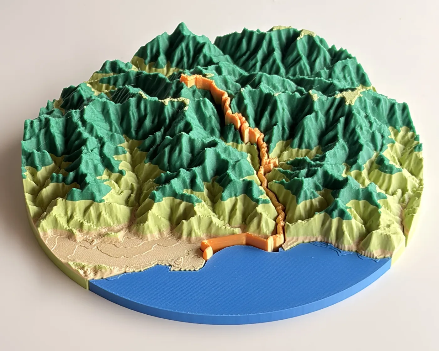
TrailMark3D builds the real terrain around your route from elevation data, raises or carves the trail into it, and adds the sea, lakes and rivers, roads, landcover colors and, in cities, buildings. You can start from a GPX exported from Strava, Garmin Connect, Komoot or Wikiloc, or from any place you search for, with no GPX at all. The 3MF download holds the land, the water and the trail as separate parts, each already assigned to its own filament, so it opens in color in Bambu Studio, OrcaSlicer and PrusaSlicer. It can also cut the map into a jigsaw puzzle, build a frame with your text on it, and print a multi-day trip day by day.

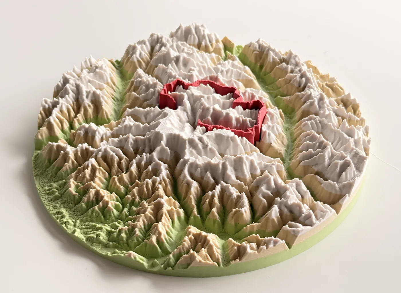
Best for: a display-ready map of a hike, ride or race on a multi-color printer, or a 3D map of a place you didn't record. Less suited to: a quick model of only the route line or its elevation profile, which GPXtruder does in one click. The free plan makes 5 models a day of areas up to 200 km across; Pro adds higher terrain detail, multi-day trips and commercial use.
The other tools, in brief
Printed Canyon makes terrain from a GPX file of up to 10 MB, a place search, a country or a US state, with the route raised, recessed or as its own part, and city maps up to 30 km across with buildings, roads, water and parks as parts of a multi-color 3MF. It downloads STL, 3MF and GLB and is pay what you want. Its pages don't mention puzzles, frames or landcover colors.
TerraPrinter turns any place you search or draw on the map, on Earth and even on Mars or the Moon, into terrain with buildings, roads and water, and downloads STL or 3MF. Beyond plain maps it has dozens of gift models, from keychains and lithophanes to a race medal with your GPX route on the real terrain. It's free for personal use and for selling up to $5,000 a year with a TerraPrinter credit. Most of its models start from a place, not from a GPX file.
GPXtruder extrudes the route itself, not the terrain around it, as a ribbon, a straight elevation profile or a ring, and exports an STL plus OpenSCAD code. It's free and open source, reads the elevations from the GPX and uses only the first track. It doesn't model the land around the route or export a 3MF.
GPXTrack.xyz turns a GPX track into a figurine of the route itself on a base, with text, and downloads a 3MF. It runs in the browser, is free and open source, and doesn't model the terrain.
TouchTerrain, from Iowa State University, turns an area on the map or a KML polygon into terrain only, as STL, OBJ or GeoTIFF, free within processing quotas. It doesn't export a multi-color 3MF.
TopoTrail is listed as a free web tool that makes terrain along a GPX route with separate colors for water, land, rock and the trail. Its site didn't load when we checked, so this comes from its directory listing.
MeshQuad Topo, at topo.meshquad.com, makes terrain from any place on the map, with a track from a GPX file or a trail picked on the map, as magnets, keychains, frames, coasters and wall art with labels and color layers. Every export is a 3MF, with a ZIP of one STL per part. Designing in its browser studio is free, and you pay once for each model you take away, at a price shown in the app.
CartTerra makes terrain from a drawn area or a GeoJSON, KML or Shapefile boundary, with STL, 3MF and GLB downloads, for $4.99 a model plus $1 per extra format. It doesn't import GPX routes.
TrailPrint3D is a free Blender add-on that turns a GPX track or any place into a terrain map with buildings, roads, water and contour lines, with map features such as forests, lakes and cities colored from OpenStreetMap, plus frames, puzzles and several shapes, and exports STL or 3MF. Version 4.0.0 came out on 7 November 2026. Several GPX tracks on one map, multi-tile maps and GeoJSON outlines are in its paid Premium tier. You need Blender installed to use it.
Looking for a GPXtruder alternative?
GPXtruder models the route line, so most people looking for an alternative want what it doesn't do: the terrain around the route, a 3MF, or colors.
- For terrain with the route on it in several colors, use TrailMark3D.
- For terrain with no route, use TrailMark3D's place search, or TouchTerrain.
- For the elevation profile, GPXtruder is still the simplest, and GPXTrack.xyz makes a figurine of the route.
Looking for a Map2Model alternative?
Map2Model, a free web app that turned an OpenStreetMap area into a multi-color 3MF for the AMS (its listing), is offline: its site now says it was shut down after legal notices. For the same kind of model, use City Mode in TrailMark3D. Search the city, switch on buildings, roads and water, pick a filament color for each, and download a multi-color 3MF that's ready for an AMS. Building and previewing a City Mode map is free with an account; downloading it needs Pro, or a new account's first 3 days.
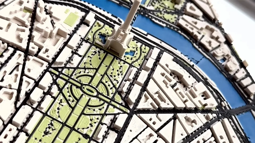
Open Map Features, where City Mode is, on the sample trail
How to choose
- Do you want the terrain, or only the route? For the land around the route, rule out GPXtruder. For a profile, it's the quickest.
- How many colors will you print? For two or more, pick a tool that exports a 3MF with separate parts, or you'll split and color the model in the slicer yourself. See STL vs 3MF.
- Do you have a GPX? Without one, use a tool with a place search (TrailMark3D, Printed Canyon, TerraPrinter, MeshQuad Topo) or a drawn area (TouchTerrain, CartTerra).
- Do you want to install anything? Every tool here runs in a browser except TrailPrint3D, which needs Blender.
- Will you sell the prints? Check each tool's terms. On TrailMark3D, selling prints needs a Pro plan.
Convert a GPX to STL or 3MF with TrailMark3D
Export the GPX from your app (see how to export a GPX from Strava, Garmin or Komoot), drop it on the TrailMark3D home page, pick a shape, generate, and download a 3MF or the STL files. The full walkthrough, with a screenshot of every step, is in GPX to STL or 3MF.
Frequently asked questions
Is it free to convert a GPX to STL?
Yes, with most of these tools. GPXtruder and TouchTerrain are free, Printed Canyon is pay what you want, and TrailMark3D has a free plan that makes 5 models a day and downloads both STL and 3MF. CartTerra charges per model.
What is the best free GPX to STL converter?
It depends on the model you want. For a terrain map with your route on it, TrailMark3D's free plan and Printed Canyon both make one in the browser. For a model of the route line or its elevation profile, GPXtruder and GPXTrack.xyz are free and open source.
Can I convert a GPX to 3MF instead of STL?
Yes. TrailMark3D, Printed Canyon, TerraPrinter, MeshQuad Topo, TrailPrint3D and CartTerra export 3MF. A 3MF keeps the trail, the terrain and the water as separate parts with their colors, so a multi-color printer such as a Bambu Lab with an AMS prints them without any splitting in the slicer.
Does my GPX file need elevation data?
For GPXtruder, yes, because it builds the model from the GPX's own elevations. Tools that model the terrain, such as TrailMark3D, take the elevation from terrain data and use the GPX only for the route's position, so a GPX without elevations works.
Can I turn a Strava activity into an STL?
Yes. Export the activity or route from Strava as a GPX file, then open it in any of the GPX tools above. Strava's export steps are in how to export a GPX from Strava, Garmin or Komoot.
Which tool works without a GPX file?
TrailMark3D, Printed Canyon, TerraPrinter and MeshQuad Topo can start from a place search, TrailPrint3D from any place in Blender, and TouchTerrain and CartTerra from an area you draw on the map.
What happened to Map2Model?
Map2Model's site says it was shut down after its creator received legal notices. TrailMark3D's City Mode makes the same kind of multi-color city map from any place you search for, with buildings, roads and water as separate parts in the 3MF.